
Historical Perspective on Sunset Airpark - North Plains, Oregon
Please support our legal challenge opposing expansion at the Sunset Airpark with a donation to Oregon Aviation Watch (OAW). To contribute, just click on the Donate tab at the top of this page. OAW is a 501(c)(3) all volunteer organization. Contributions are tax deductible.
Introduction
In November 2013 Oregon Aviation Watch (OAW) announced that it had joined with the Washington County Citizen Action Network (WC CAN) in a Land Use Board of Appeals (LUBA) challenge to Ordinance 772. The passage of this ordinance by the Washington County Board of Commissioners on 10/22/13 created the county's first "residential airport overlay district (RAOD)." It allows for the construction of aircraft hangars of unlimited size on 18 residential properties at Sunset Orchard Estates - a subdivision owned by Robert and April Jossy,[1] located adjacent to the Sunset Airpark approximately one mile from North Plains, Oregon. The subdivision properties are zoned for rural residential (RR-5) and agricultural and forestry (AF-5) uses.
Ordinance 772 also allows for the construction of taxiways and tie-down areas as well as the storage of leaded aviation fuel on the 18 parcels, all of which are located outside the existing airport boundary.
Future residents of the subdivision will be able to purchase easements from the airpark owner, Roth Development, to gain access to the existing Sunset runway and taxiway from their individual properties. Though a traditional farming community, the current airpark residents are hoping that only pilots will live in the subdivision.
Hillsboro Airport (HIO), the busiest general aviation airport in the state, is 4.7 miles from the Sunset Airpark and the proposed "residential airport overlay district." HIO typically logs close to a quarter million operations per year. The majority are student pilots who engage in repetitive training maneuvers, touch and go's, at altitudes of 2,000 feet or below within 4 to 5 miles of HIO. The city of North Plains is located within Hillsboro Airport controlled airspace.[2]
Due in part to safety concerns, a Letter of Agreement between Roth Development and the Federal Aviation Administration (FAA) requires that "Pilots of aircraft using the Sunset Airpark shall remain at or below 500 ft. AGL while in the Hillsboro Class D surface area." Hillsboro Airport Class D airspace extends outward in a 4.2 mile radius from the Hillsboro Airport[3] and includes populated parts of the city of North Plains.
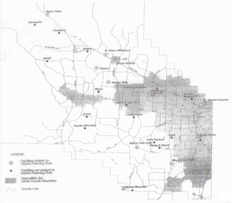
Also contributing to the congestion, noise, pollution, and safety risks are the 2 private use and 1 privately owned public use airports located on Exclusive Farm Use lands (EFU) within 3 miles of the Sunset Airpark - North Plains Gliderport, Olinger Strip, and Skyport Airport, respectively. The overlay zone of the North Plains Gliderport extends over the western boundary of the city of North Plains. In addition, there are two other Washington County airports in close proximity - Apple Valley 10.5 miles to the west of Sunset Airpark in Buxton, and Stark's Twin Oaks 11.7 miles south in Hillsboro.
This article provides historical information on the Sunset Airpark and further elucidates why expanding airport uses at and adjacent to this airpark poses serious safety risks to the community, represents a significant restriction on lands set aside for farming and agricultural uses, and erodes livability due to noise and pollution.
Roth Development Corporation - Owners of Sunset Airpark
The Sunset Airpark is owned by Roth Development Corporation, which is composed of 11 property owners at the Sunset Airpark. The company's current president is Bill McCandless, a pilot and resident of the airpark.
Roth Development was initially formed more than 40 years ago by Dr. John Roth, a pilot, and his brother, Merrill "Rod" Roth, a home developer who was elected in 1972 to serve a term as a Washington County Commissioner. Both were officers and stockholders in the corporation. In the late 1960s they embarked on a search for land west of Portland to build a residential airpark. Their goal was to find a property large enough "to provide for a runway at least 2,000 feet long, at least nine large building sites and a location within normal suburban commuting distances of the city of Portland."[4]
1967 FAA Denial of Meek Rd. Residential Airpark Proposal
Their first consideration was a property just south of Meek Rd. within 2 1/3 miles of the Hillsboro Airport. The Roth Corporation proposed building a 2200 foot runway on this site[5] - an option that was ultimately abandoned due to opposition from various sources.
In an 8/11/67 letter, then-FAA Area Manager, Robert Blanchard informed Merrill Roth that,
It has been determined that the proposed airport would adversely affect the safe and efficient use of airspace by aircraft due to its proximity to the existing Portland-Hillsboro Airport. Establishment of the proposed airport would adversely affect the safety of aircraft operating from the Portland-Hillsboro Airport as well as those operating from the new airport.[6]
The Port of Portland also opposed this location. Records from a State of Oregon Aeronautics hearing referred to comments from Roland Smith from the Port of Portland:
The General Aviation Division, Port of Portland, is opposed to the approval of the strip for traffic conflict reasons. Their future development plans would make runway 12 an ILS [Instrument Landing System] runway and this site would be in the approach area. He felt that this airport is not needed since it is less than two miles from a General Aviation Airport.[7]
As noted by Merrill Roth, property owners within the vicinity of the Meek Rd. location were also opposed:
After the Board [of Aeronautics] granted approval of this site (over the objection of the Port of Portland) we learned that the proximity of certain neighbors would make it impossible to operate unless appropriate airspace easements were obtained. These airspace easements were either not available or available only at an exorbitant price.[8]
As a result of these objections, Roth Development sought approval for an alternate location a few miles farther west, one that eventually became the present site of the Sunset Residential Airpark.
Sunset Airpark Established in 1970
The Sunset Residential Airpark was initially intended to serve a maximum of 25 families, all of whom would have access to the airport runway from their individual properties. The proposed runway at the Sunset location was significantly longer and wider than the Meek Rd. site - 3050 feet long and 200 feet wide. According to Federal Aviation Administration (FAA) documentation, Roth Development estimated that, if approved, "there will be 12 aircraft based at the site within 5 years. The airport is proposed as a limited private use airport to serve residential development. 150 monthly operations are planned within 5 years."[9]
After extensive negotiations, on 1/20/70 Sunset Airpark was approved as a personal use residential airpark with the stipulation that "No more than 25 families with aircraft shall have easements for the use of this airstrip at any one time." To address the safety concerns identified by the Port of Portland and the FAA, the agreement required coordination and communication with the Hillsboro Airport tower for arrivals, departures, traffic patterns and other air traffic control instructions and further stated that, "In the event it became necessary for the operation of Portland-Hillsboro Airport, Roth Development, Inc., agrees to grant to the Port of Portland, without charge, airspace easements over the runway and taxiways at Sunset Air Strip."[10] At this time there were only 5 based aircraft at the site. Within a few years this number more than doubled.
Port of Portland Opposition - Safety Concerns and HIO Expansion Plans Key Factors
Though ultimately approved, the siting of the Sunset Airpark met with strenuous opposition from the Port of Portland. Moreover, the Sunset Airpark is located within the Hillsboro Airport control zone. Testimony submitted on 12/14/67 by then-Port of Portland General Aviation Manager, Roland Smith, detailed the Port's objections:
- The location of this strip is directly on the extended center line of runway 12, proposed and designated instrument runway for Portland-Hillsboro Airport. In this proposed location, traffic for this air strip would definitely reduce the instrumentation capability and in all probability would preclude the FAA's designation of our runway 12-30 as an instrument runway.
- This objection is from a flight safety standpoint. A landing strip in this particular area will generate traffic within the approach zone and directly in the path of landing or takeoff from runway 12. This would create a hazardous condition.
- We question the need of an airport in this particular area in view of the fact that the Port of Portland is developing the Hillsboro Airport to maximum capability as a general aviation airport. This includes extending runway 12-30 to 5400 feet giving it instrument capability.
In conclusion it is felt that although the proposed airport is further out, it is a far more hazardous location than the originally proposed airport off of Meek Road. This is due to its location on the extended center line with the approach zone. The original proposed airport, although closer in, was 3,000 feet northeast of the center line and outside of the 50:1 approach portion of the zone.[11]
Supplemental hearing testimony submitted by Smith on 2/8/68 revealed ambitious Port of Portland expansion plans "to develop two fully instrumental general aviation airports capable of being expanded to serve aviation related industrial requirements and possibly to finally become the metropolitan area's second commercial airport or airports."
In all, we are planning five to seven possible airports in the metropolitan area. Some of these airports are already in existence and will be expanded - others will be created. By its geographical location and other ideal considerations, the Portland Hillsboro Airport will be the first and the largest of this airport family to be completely developed. This long range planning and expenditure of public funds is designed to furnish the flying public in the metropolitan area such as the proponents of this flight strip with adequate and convenient airports within fifteen or twenty minutes of their homes or businesses. Therefore, we cannot see the need of an airport within the control zone nine minutes by road away from a fully instrumented general aviation airport with all attending facilities.
We wish to reiterate our objection to this flight strip from a flight safety standpoint. This particular proposed location will generate traffic within the approach zone and directly in the path of landing or take-off from Runway 12. This is creating a hazardous condition. At the present, this type of traffic is already being generated from the Olinger Strip which is not located on an extended center line but is located west and north of the airport and is within the control zone. We believe this traffic also creates a hazardous condition but there is nothing that can be done about the Olinger Strip as it was in existence prior to the Port's taking over the Portland-Hillsboro Airport.[12]
On 5/13/68 Mr. Smith submitted additional supplemental information explaining a change to the Port's and FAA HIO Runway 12/30 extension plan. In this regard he further elaborated on the Port's objections to the Sunset Airpark.
At the present time, we are planning to extend the runway 2,060 feet instead of 1,350 feet in the original plan. This means that the 50:1 approach zone would run out as indicated with an elevation of 207 feet AGL and the 40:1 criteria beyond that would show a clearance of only 447 feet AGL just south and adjacent of the proposed Roth strip. As can be seen, a 500-foot traffic pattern to this strip would penetrate this clearance altitude. We believe that this would further compromise not only the safety of an instrument approach but would further jeopardize FAA participation in a program to instrument this runway at Portland-Hillsboro Airport.[13]
Then and Now
By 2013, runway 12/30 had been extended to 6,600 feet. It is noteworthy that between 1967 and 1971 the annual operational count at the Hillsboro Airport declined from 101,784 to 80,787. Each of the 153 based aircraft at HIO in 1971 averaged approximately 536 operations per year.[14]
Fast forwarding from 1971 to 2013, the annual operational count at HIO has more than doubled. Local flights, which consist primarily of touch and go training operations, have increased more than 3-fold.
Hillsboro Aviation, a fixed based operator at the Hillsboro Airport, runs one of the largest combined helicopter and airplane flight training schools in the Pacific Northwest. The school logs more than 63,000 hours annually[15] which translates on average to more than 7 aircraft in the air 24 hours per day, 7 days per week, every single day of the year. Please note this figure applies only to the Hillsboro Aviation flight school and does not include corporate jet traffic, recreational flying and other fight activity at this airport.
In addition, two other Washington County airports - Stark's Twin Oaks and Skyport Airport - are also involved in the flight training business.
This enormous amount of air traffic suggests that the safety hazards identified by the Port in the late 1960s have substantially increased with the expansion of the Hillsboro Airport over the ensuing years as well as the build up of other airports throughout the region. Stark's Twin Oaks, Skyport, North Plains Gliderport and the Apple Valley Airstrip were not in existence in 1970 when the Sunset Airpark was initially approved.
1973 Proposal to Increase Family Access to Sunset Airpark to 50 or 100
In 1973, within 3 years of approval as a residential facility to accommodate no more than 25 families and despite the safety issues previously raised by the Port of Portland and the FAA, Roth Development actively advocated to increase the number of families with access to this airport. A 3/20/73 letter from then-Executive Director of the Port of Portland, Edward Westerdahl, stated, "This week the Port received a telephone call from Roth Development, Inc. asking for our concurrence to increase the number of families using their Sunset Airstrip to 100."[16] Other letters spoke of an increase to 50.[17] A letter from Roth's attorneys claimed that, "The fair market value of the lots which adjoin the airstrip will be substantially impaired if this requested increase is not approved. Further A.R. John General Contractors. Inc., will suffer direct, ascertainable and substantial damages if development of the site is further delayed."[18]
So even though the airpark was approved for no more than 25 families, Roth Development was already aggressively pushing to significantly expand the airstrip by doubling or quadrupling the number of families with access to the runway.
In response the Port of Portland Board of Commissioners voted to "delay a modification of the Sunset Airstrip license until after completion of the Port-Hillsboro Airport Master Planning Study," and pointed out that the initial agreement stated that, "In the event it becomes necessary for the operation of the Hillsboro Airport, Roth Development, Inc. agrees to grant to the Port of Portland, without charge, airspace easements over the runway and taxiways at Sunset Airstrip."[19]
City of North Plains Position on the 1970 Sunset Airpark Proposal
According to a 12/18/67 interoffice memo from the State of Oregon on the Sunset Airpark site hearing, Glen Sanford, Mayor of North Plains, spoke in favor of the Sunset proposal if the air strip traffic patterns were not over the existing City.[20]
It appears that Mr. Sanford's request was initially honored, but this all changed in 2003 when the Washington County Board of Commissioners passed Ordinance 609. This ordinance designated the Sunset Airpark as a private airport authorized to engage in commercial activities at some point in the future. It also established a Sunset Airpark overlay zone that placed restrictions on neighboring property owners. This zone extends north across Highway 26 and continues over the city of North Plains.
It is now routine for Sunset Airpark pilots to land and take off over North Plains. An excerpt from the Washington County Board of Commissioners 9/24/13 Meeting Minutes on Ordinance 772 included the following summary on testimony from Bill McCandless, the current President of Roth Development:
He said they are aware of the intensive flight training activity out of the Hillsboro Airport and go out of their way to avoid it. He said they are sensitive to North Plains and will avoid taking off in that direction unless increased winds dictate otherwise. He said that landings take place in that direction because they try to avoid the intensive glider activity at the North Plains glider port.[21]
Though not discussed during the hearing, it is also reasonable to assume that Sunset Airpark pilots also avoid flying west of the airstrip due to the flight training activity associated with the privately owned, public use Skyport Airstrip located just 2.2 miles to the west of Sunset. During the 12 months ending on 9/9/13, Skyport logged 750 local (touch and go) training flights and 1,250 itinerant flights for a total of 2,000 total operations.[22] It is not altogether clear why this airport is designated as a public use airport as it did not meet state criteria of having 3 based aircraft on site in 1996.
Further complicating airspace usage are the restrictions already in place east of the Sunset Airpark because of Hillsboro Airport activity.
Clustering of Airports in the Vicinity of the Sunset Airpark
As a result of the 2003 passage of Ordinance 609, a number of airports clustered in close proximity to North Plains and within five miles of the Hillsboro Airport, have been accorded private, public or private/public status and are approved for possible future commercial expansion. These include:
- Hillsboro Airport - 4.7 miles from the Sunset Airpark. Logs nearly a quarter million annual take-offs and landings. The vast majority, 80-90 %, are flight training operations. This airport is the largest source of lead emissions in the state. On a list of 512 lead sources within Oregon, HIO surpasses both Cascade Steel and PGE Boardman in emissions of this neurotoxin.[23]
- Skyport - located in Cornelius, 2.2 miles from the Sunset Airpark and 5 miles from the Hillsboro Airport (HIO) is a privately owned, public use facility. In 2003 it did not meet state criteria for private or public airport status. This facility is the 4th largest source of lead in Washington County.[24]
- Olinger Residential Airstrip - located in Hillsboro within 2.7 miles of the Sunset Airpark and 3 miles from HIO. There are 12 single engine aircraft and 1 ultralight based at this facility. This facility is the 7th largest lead source in Washington County.[25]
- North Plains Gliderport - located less than 1.5 miles from the Sunset Airpark and 5 miles from HIO. There are 2 single engine aircraft and 12 gliders based at the glideport. The eastern end of the overlay zone for this facility was extended over the City of North Plains in 2003. This section of the runway accommodates the bulk of the air traffic landings and take-offs, as during the 2003 Ordinance 609 hearings, property owners to the west of the gliderport threatened a takings claim. The property owners hired attorney Phillip Grillo from the Miller Nash LLP legal firm to represent their case at the time. They expressed concern about the height restrictions and limitations placed on their property for the sole benefit of the gliderport.[26] This facility is the 6th largest lead source in Washington County.[27]
In addition to the airports discussed above there are two other Ordinance 609 airports located within 12 miles of the Sunset Airpark.
- Apple Valley Airport in Buxton is 10.5 miles west of the Sunset Airpark. It was first approved as a personal use airstrip in 1989. In recent years, area residents have invested well over $150,000 in legal expenses to oppose efforts by Apple Valley owners, Mike and Jenni Applebee, to develop this airport into a commercial facility that accommodates flight training and sight-seeing tours. There are currently 10 helicopters and 2 fixed wing aircraft based at this facility.[28] This facility is the 8th largest lead source in Washington County.[29]
- Stark's Twin Oaks is located 11.7 miles south of the Sunset Airpark and 6 miles from HIO. Operations in the 12 months ending on 6/13/12 totaled 22,195, with 5,570 listed as local (touch and go training flights) and the remainder as itinerant. There are 113 aircraft based at this facility - 107 single engine, 1 multi-engine, 4 helicopters and 1 ultralight.[30] This airport, is the second largest lead source in Washington County.[31]
It is unclear as to why the State of Oregon and Washington County are promoting these airports for future growth in light of the serious safety hazards identified by the Port of Portland more than 40 years ago when the Sunset Airpark location was first proposed. Documentation of these concerns is currently available in the Oregon Department of Aviation file on this facility. The North Plains Gliderpark, Skyport Airstrip, Apple Valley, and Stark's Twin Oaks did not exist in 1970 when the Sunset Airpark was first approved.
North Plains and surrounding communities are now subject to air traffic congestion as well as the noise, pollution, security and safety risks that accompany this massive increase in aviation activity. Nearly a ton of aviation-generated lead emissions are released over Washington County annually during the landing and take-off phase of HIO flights. Additional tonnage is released during the cruise phase. According to EPA estimates for 2008, in addition to the lead released at individual airports during the landing and take-off phase of flight, an additional 5.3 tons of lead were released over Oregon during the cruise phase.[32] Smaller airports throughout the area are also contributing to this highly toxic situation. Lead is a suspected carcinogen with serious health impacts. Its pernicious effects in children even at very low blood lead levels include lower IQs, ADHD, behavior problems, and learning disabilities. Lead exposure in adults is associated with cardiovascular disease, kidney ailments, dementia, and miscarriages.
Sadly, it appears that the Washington County Board of Commissioners failed to consider noise pollution and the serious safety risks delineated by the Port of Portland in the Oregon Department of Aviation file on the Sunset Airpark.
More than 40 years ago, the Port of Portland opposed siting the Sunset Airpark within less than 5 miles of the Hillsboro Airport and identified the Olinger Strip as a significant safety hazard. Yet now there are 4 airports, including the largest general aviation airport in the entire state, within less than 5 miles of the Sunset Airpark and two more less than 12 miles away.
Airports Encroach on Farmland
According to the Land Conservation and Development Commission (LCDC), "Hangars and taxiways are not permissible accessory uses on EFU and AF 20 zoned lands because airports are not permissible in these zones, unless an exception is taken."[33] In response to LCDC's position on this issue, 3 EFU parcels and one AF-20 parcel were removed from the proposed Sunset Airpark Residential Airpark Overlay District prior to the passage of Ordinance 772.
The proposed Sunset Airpark expansion provides an example of how rapidly diminishing farm land in Washington County is coming under attack by the aviation enthusiasts. Particularly insofar as the Sunset Airpark Homeowner's Association is intent on restricting traditional agricultural activity in an attempt to promote aviation interests.
Though the location of the Sunset Airpark is in a rural area, a review of the Roth Development Inc. Declaration of Covenant and Restrictions[34] that apply to the airpark reveals that the current rules place significant restrictions on current farm practices. For instance, Article II of the covenant, entitled Residential Use Only, allows outbuildings such as garages, greenhouses, guest houses, servants' quarters and airplane hangars, yet prohibits building a stable. Article III prohibits fowl, livestock, horses, and other animals, excepting dogs, cats, and other household pets.
It is also noteworthy that many of the airports discussed in the previous section are also contributing to the loss of agricultural lands throughout the county. Prior to the passage of Ordinance 609, several were described as non-conforming uses and are located on Exclusive Farm Land or are in AF 20 districts. The following quotes from a 9/9/03 Washington County Board of Commissioners Staff Report on Ordinance 609 further elaborates on this point.[35]
- Sunset Airpark: "The airstrip is considered an (unofficial) nonconforming use is the AF-5 District, and the associated house lots are split among the AF-5 and RR-5 Districts"
- The Apple Valley Airstrip "crosses three tax lots in the EFU and AF-20 land use districts."
- North Plains Gliderport "is considered to be a nonconforming use in the EFU District."
- Olinger Strip "is a collectively-owned, non-profit airstrip in the EFU District that is considered to be (unofficially) nonconforming."
- Skyport Airport "was not identified by the state for required local airport planning. This airport includes a gravel runway, pilots' lounge and tie down areas, occupying portions of two tax lots in the EFU District. Conditional use approval of the airport was granted in 1973. The Department of Aviation reports three aircraft based at this facility, and most recent air traffic monitoring estimates 710 flights annually."
- Stark's Twin Oaks is in an AF-5 district.
Aviation Accident History
A review of the National Transportation Safety Board[36] records reveals that Port of Portland concerns regarding safety hazards were well founded. Since Sunset Airstrip was established there have been scores of aviation accidents in North Plains, Hillsboro, Cornelius, Banks, Forest Grove, and the surrounding communities. With the massive increase in aviation activity throughout Washington County over the past 45 years, area residents are increasingly at risk.
Accidents in the Vicinity of North Plains and the Sunset Airpark
A review of the National Transportation Board database revealed that between 1970 and 2006, there were at least 18 accidents in North Plains, including five fatalities. The most recent occurred in 2006 when a pilot, after departed from the Hillsboro Airport (HIO), crashed in a filbert orchard adjacent to the Sunset Airpark. He was practicing ILS maneuvers at the time. The cause of the crash was attributed to the pilot's failure to maintain air speed during a forced landing.
Another pilot perished in October of 1995, when an experimental aircraft that had departed from the Sunset Airstrip 40 minutes earlier crashed in Forest Grove.
In addition, a North Plains 1982 accident claimed the lives of a flight instructor and student pilot when their helicopter crashed on a stormy night with gusty winds and poor visibility due to clouds and fog. The cause was attributed to inadequate pre-flight planning.
There were also several non-fatal North Plains accidents including a 10/7/95 aircraft crash when due to "fuel starvation" a pilot landed in a field of raspberries 1/8 mile from the Sunset Airstrip as well as an 8/13/73 accident when a pilot who intended to land at the Sunset Airpark crashed in Hillsboro.
Since 1995 at least eleven accidents have been associated with the North Plains Gliderport. An additional five accidents, which occurred between 1970 and 1981, including one fatality, were linked with the North Plains Eagle Gliderport.
Accident in Mountaindale
Mountaindale, located approximately 4 mile northwest of North Plains, was the site of a 2/19/84 accident. Three people perished when a Piper, while preparing to land at the Hillsboro Airport, crashed. Overcast skies and foggy weather conditions were cited as contributing factors.
Accidents in Cornelius
Several accidents have also occurred at the Skyport Airport, located in Cornelius 2.2 miles from the Sunset Airpark. Two were related to flight training. On 10/20/11 a Cessna registered to Hillsboro Aviation was damaged when the aircraft bounced upon landing after the flight instructor simulated an engine power failure. On 5/19/06 a helicopter registered to Applebee Aviation in Banks, Oregon was damaged during a landing maneuver. A flight instructor and student were on board at the time.
Other Cornelius accidents occurred on 7/25/96 when a pilot sustained a serious injury while crop spraying and on 11/27/87 when a pilot crashed into power line and a tree while trying to land in a field.
Olinger Strip
Olinger Residential Airstrip is located in Hillsboro less than 3 miles from the Sunset Airpark. There are at least 4 accidents linked with this site including a 5/18/04 fatality when a pilot who intended to land at the Olinger Strip crashed in Molalla during a cross country flight.
Stark's Twin Oaks
Aircraft registered to or arrivals, departures and training flights linked with Stark's Twins Oaks have also been in a number of accidents. Of the 31 accidents listed, 9 involved student pilots and/or instructional flights. There were 6 fatalities, including a pilot who died on 10/25/11 when his aircraft, which originated from Stark's Twin Oaks, collided with an aircraft registered to Hillsboro Aviation and piloted by a flight instructor and student in training. The instructional flight had been practicing maneuvers over the Champoeg State Park.
Hillsboro Airport
Per NTSB records, the largest number of aviation accidents - close to 100 including 23 fatalities - are associated with aircraft in route to or departing from the Hillsboro Airport or during the landing and take-off phase of flight. Some of these aircraft crashed on residential properties.
- A pilot died during the 2006 Oregon Airshow when his static display aircraft crashed into a Hillsboro residential community. One home was destroyed and three others were damaged. The aircraft, which had 588.6 gallons of jet fuel on board at the time, ignited a major fire.
- On 6/15/07, shortly after departing from the Hillsboro Airport, an aircraft crashed in a southwest Portland neighborhood. All three people on board, including a 12 year old boy, were killed. Weather conditions were described as cloudy and overcast.[37]
- On 4/2/08, "A small plane flying in dense fog crashed into a residential property in rural Yamhill County, killing two Salem-area colleagues and narrowly missing a neighbor walking his dog."[38] The occupants of the aircraft routinely flew to their Hillsboro area jobs. One was an engineer employed by Intel.
Student pilots have also made forced landings in schoolyards in nearby communities.
- In November of 2012 a helicopter registered to Hillsboro Aviation, piloted by a flight instructor and student in training, made an emergency landing at the Robert Gray Middle School in Southwest Portland.[39]
- Two years earlier, in October of 2010, a flight instructor from Snohomish, Washington barely avoided crashing into a home before making a forced landing at the Robert Gray School. His plane ran out of gas.[40]
Many of the Hillsboro Airport accidents, more than 25%, involve flight training operations. A significant percentage of the aircraft were registered to Hillsboro Aviation, which runs one of the largest flight training schools in the Pacific Northwest out of the Hillsboro Airport. Their predecessor, Hillsboro Helicopter, was also linked to a number of accidents as was Eagle Flight Training, a company which used to be based at the Hillsboro Airport. Recreational pilots and experimental aircraft owners were also involved in a number of accidents.
Banks and Forest Grove Accidents
The accidents listed for Banks, located 6 miles west of North Plains, included one fatality which occurred on 6/17/00. A pilot with an accumulated total of 133 flight hours died when his experimental, homebuilt aircraft crashed. In addition, on 4/22/07 a glider originating from the North Plains Gliderport was damaged when the pilot made a forced landing in a field.
There were also 7 accidents linked with Forest Grove, a community which is approximately 8 miles from North Plains. The two that involved fatalities were discussed earlier in this report.
Conclusion
In the 1973, the Port of Portland took a formal stance against the development of private general aviation airports throughout the region: "this type of airport development should be generally discouraged because of its diluting effect on the quality of existing airport facilities. The large number of small airports makes the development of high quality facilities difficult to justify or finance." In addition, the Port argued that future general aviation growth should be "directed towards developing fewer airports to insure that the quality of the airport facilities are maintained and improved."[41]
The Port's concerns about the difficulty of financing multiple general aviation airports proved to be accurate. Port of Portland Ordinance No. 389-R Section 1.1.6 acknowledged that their general aviation airports, "Portland Hillsboro Airport, Portland Mulino Airport, and Portland Troutdale Airport have sustained net losses throughout their respective periods of operation by the Port and have never produced revenues sufficient to offset the Port's operating and capital costs for aeronautical assets in use at such airports"[42] The Port has owned and operated the Hillsboro Airport for 46 years, Troutdale Airport for 70 years and Mulino Airport from 1988 to 2007.
Other airports around the state are also chronically dependent on public handouts. According to the Oregon Department of Aviation ODA 2011-2012 Annual Report,[43] the ODA owns and operates 28 state airports. All but six of these facilities lost money during the biennium ending in June of 2011. See Oregon's Skewed Funding Priorities for additional information on airport funding in Oregon.
Another valid issue cited by the Port was safety, "overlapping airspace requirements of these airports creates hazards to aircraft and jeopardizes safe operations within the system."[44] The above discussion of the accident history associated with Washington County airports certainly indicates that the Port's concern were well justified.
This is also borne out in a 2007 article in the Journal of the American Medical Association (JAMA), "From 2002 through 2005, general aviation, with an annual average of 1685 crashes and 583 deaths comprised 91% of all aviation crashes and 94% of all aviation fatalities. The crash rate for general aviation, 1.31 fatal crashes per 100,000 flight hours, is 82 times the rate for major airlines (0.016), this difference in crash rates has persisted over many decades." The article further stated that, "Due to their relatively small aircraft size and low altitude, general aviation flights are especially vulnerable to adverse weather conditions. Partly reflecting inadequate training and flight experience, pilot error is a contributing factor in 85% of general aviation crashes compared with 38% of airline crashes."[45]
Keeping in mind that Hillsboro Aviation's flight training school alone logs 63,000 flight hours annually and based on the crash rate of 1.31 fatal crashes per 100,000 hours flown statistically averages 0.82 fatal crashes per year. Some of these accidents involve the death of more than one person. As the population of Washington County continues to grow, the risk of serious injury or death to people on the ground increases substantially.
With companies such as Hillsboro Aviation assuring prospective pilots that, "learning to fly in challenging weather is a critical part of becoming a well-rounded pilot,"[46] it is reasonable to assume that weather-related accidents will continue to pose serious risks throughout Washington County both to pilots in training and to residents on the ground. The requirement that student pilots accumulate night-time training hours is also of concern as there is an amplified risk of accidents due to poor visibility at night.
The Aviation Sciences pilot training program at the Rock Creek Portland Community College campus further adds to the already very serious noise, pollution and accident risk resulting from aviation activity in Washington County.
All of the objections to the Sunset Airpark cited by the Port and the FAA more than 40 years ago have only become more compelling in light of the enormous increase in general aviation activity, especially flight training at HIO and nearby airports. A significant number of airports that engage in these activities are subsidized at public expense via commercial passenger fees and Connect Oregon funding. Out of respect for the safety and well-being of area residents, aviation activity throughout the entire jurisdiction should be significantly curtailed rather than increased. In addition, the public deserves explanations from the state and local elected representatives as to why they are so willing to invest scarce public resources into championing for-profit flight training, sight-seeing tours, recreational flying and other non-essential activities at the expense of protecting livability, preserving rapidly diminishing farmland, and exercising responsible stewardship over scarce public resources.
Much of the source material cited in this article can be accessed on the OAW Legal Page under the Ordinance 772 section at the top of the page.
Sources
[1] Back, Andy. Staff Report on Ordinance Number 772 for 9/4/13 Washington County Planning Commission Meeting. (8/28/13). Pg. 3.
[2] Chapter 17. Class D Airspace. Section 2. Class D Airspace Standards. FAA. Order JO 7400.2J. (Effective Date 2/9/12). Available at http://www.faa.gov/air_traffic/publications/atpubs/AIR/air1702.html.
[3] Federal Register Volume 78, Number 101 (Friday, May 24, 2013). Pages 31395-31397. Available online at http://www.gpo.gov/fdsys/pkg/FR-2013-05-24/html/2013-12314.htm.
[4] Roth, Merrill. Testimony In The Matter of the Application of Roth Development Corporation for Airport Site Approval Before the Oregon State Board of Aeronautics. (3/8/68).
[5] Federal Aviation Notice of Landing Area. Residential Airpark Proposal Submitted by Roth Development Corporation. (5/22/67).
[6] Letter from Blanchard, Robert (FAA Area Manager) to Merill Roth. (8/11/67).
[7] Roth Development Inc. Airport Site Hearing Minutes. State of Oregon Board of Aeronautics. (Hearing held on 7/10/67).
[8] Roth, Merrill. Testimony submitted before the Oregon State Board of Aeronautics In the Matter of the Application of Roth Development Corporation for Airport Site Approval. (3/8/68).
[9] McKnight, Fred. (FAA Air Traffic Branch Chief for Oregon and Washington). Notice of Sunset Air Strip Proposal Affecting the Utilization of Airspace. Case 68-SEA-14-NR. (5/1/68).
[10] Sunset Air Strip. State of Oregon Airport License. (1/20/70).
[11] Smith, Roland (Port of Portland Manager of General Aviation). Testimony submitted at the Oregon State Board of Aeronautics Siting Hearing on the Sunset Airpark Proposal. (12/14/67).
[12] Smith, Roland (Port of Portland General Aviation Manager). Supplemental Testimony Objecting to the Sunset Airpark Proposal. (2/8/68).
[13] Smith, Roland (Port of Portland Manager of General Aviation). Supplemental Information Objecting to the Sunset Airpark Proposal. (5/13/68).
[14] R. Dixon Speas Associates, Inc. Aviation Consultants. Preliminary Draft Phase - Portland/Hillsboro Airport Master Plan Study. Chapters IV and V. (1973).
[15] Flight Training School. Hillsboro Aviation website. Available at http://www.hillsboroaviation.com/en/page/school. Accessed on 1/7/14.
[16] Letter from Westerdahl, Edward (Executive Director of the Port of Portland) to Veatch, Robert (Chairman of Oregon State Board of Aeronautics). (4/19/73)
[17] Letter from Ericsson, Lloyd (attorney) to Burkett, Paul (Aeronautics Administrator for the Oregon State Board of Aeronautics). (8/2/73).
[18] Letter from Duncan, William Bradley (Atorney Representing Roth Development) to Westerdahl, Edward (Executive Director of the Port of Portland). (4/16/73).
[19] Letter from Westerdahl, Edward (Executive Director of the Port of Portland) to Duncan, William (Attorney). (4/24/73).
[20] State of Oregon Interoffice Memo from McGinnis, Ralph to Dunn, Robert (Director of the Oregon State Board of Aeronautics). Roth Development Co. Site Hearing (North Plains). (12/18/67).
[21] Washington County Board of Commission Meeting Minutes. Ordinance 772. (9/24/13).
[22] Skyport. Airport IQ 5010. Airport Master Records and Reports. Federal Aviation Administration. Available at http://www.gcr1.com/5010web/airport.cfm?Site=4S4&AptSecNum=2.
[23] The 2011 National Emissions Inventory. EPA. (Last updated 12/24/13) Available at http://www.epa.gov/ttnchie1/net/2011inventory.html. Scroll down to Maps and Fusion Tables then click on lead and filter by state.
[24] Ibid. Scroll down to Maps and Fusion Tables then click on lead and filter by state and county.
[25] Ibid.
[26] Grillo, Phillip (Attorney). Testimony Submitted to the Washington County Board of Commissioners. (9/19/03).
[27] The 2011 National Emissions Inventory. EPA. (Last updated 12/24/13) Available at http://www.epa.gov/ttnchie1/net/2011inventory.html. Scroll down to Maps and Fusion Tables then click on lead and filter by state and county.
[28] Apple Valley Airport. Airport IQ 5010. Airport Master Records and Reports. Federal Aviation Administration. Available at http://www.gcr1.com/5010web/airport.cfm?Site=OR61&AptSecNum=2.
[29] Ibid.
[30] Starks Twin Oaks. http://www.gcr1.com/5010web/airport.cfm?Site=4S4&AptSecNum=2.
[31] The 2011 National Emissions Inventory. EPA. (Last updated 12/24/13) Available at http://www.epa.gov/ttnchie1/net/2011inventory.html. Scroll down to Maps and Fusion Tables then click on lead and filter by state and county.
[32] Calculating Piston-Engine Aircraft Airport Inventories for Lead for the 2008 National Emissions Inventory. EPA. (December 2010). Pg. 19. Available at http://www.epa.gov/otaq/regs/nonroad/aviation/420b10044.pdf.
[33] Letter Debbaut, Anne. (LCDC Metro Regional Representative) Schaefer, Paul (Senior Planner for Washington Planning and Development Services). (8/20/13).
[34] Declaration of Covenants and Restrictions Running With Land in North Plains, Washington County, Oregon. Roth Development, Inc .(8/14/71).
[35] Curtis, Brent. (Washington County Planning Manager). Staff Report on the Proposed Land Use Ordinance No. 609 - Airport Planning for the Washington County Board of Commissioners 9/16/03 Hearing. (9/9/030. Pg. 8-9.
[36] National Transportation Safety Board. North Plains, Oregon Aviation Accident Query. Available at http://www.ntsb.gov/aviationquery/index.aspx. The accidents included in this article were found by typing in the name of the city as well as by entering city and airport names into the word string line at the bottom of the query page.
[37] Killen, John. NTSB Can't Find Cause in Plane Crash That Killed Three Last June. Oregonian. (6/2/08). Available at http://blog.oregonlive.com/breakingnews/2008/06/a_singleengine_plane_that_cras.html.
[38] Crombie, Noelle. Commuter Plane Crash Kills 2 Salem-Area Residents. Oregonian (4/1/09. Available at http://www.oregonlive.com/news/index.ssf/2009/04/a_small_plane_crashed_into.html.
[39] Helicopter Makes Emergency Landing at Portland School. KATU. (11/15/12). Available at http://www.katu.com/news/local/Helicopter-makes-emergency-landing-at-Portland-school-179522411.html.
[40] Snohomish Pilot Survives Emergency Landing Near Portland School. KIROTV. (10/12/10). Available at http://www.kirotv.com/news/news/snohomish-pilot-survives-emergency-landing-near-po/nDN54/.
[41] R. Dixon Speas Associates, Inc. Aviation Consultants. Preliminary Draft Phase - Portland/Hillsboro Airport Master Plan Study. Chapters IV and V.(1973)
[42] Port of Portland. Agenda. Regular Board of Commissioners Commission Meeting. Second Reading and Enactment. Amended and Restated Ordinance No. 389-R. of the Port of Portland. (3/13/13).
[43] Oregon Department of Aviation Annual Report July 1, 2011 Through June 30, 2012, Available online at http://www.oregon.gov/aviation/docs/FY_2011_2012_Annual_Report.pdf. Pg. 40.
[44] R. Dixon Speas Associates, Inc. Aviation Consultants. Preliminary Draft Phase - Portland/Hillsboro Airport Master Plan Study. Chapters IV and V.(1973)
[45] Guohua, Li and Baker, Susan. "Crash Risk in General Aviation." Journal of the American Medical Association (JAMA). Vol. 297, No. 14. pg. 1596-1598.
[46] Airplane Flight Training. Hillsboro Aviation website. Available at http://www.hillsboroaviation.com/en/page/airplane_flight_training. Accessed on 1/7/14.
| © Oregon Aviation Watch | Contact Us |  Jump to Top Jump to Top |